Sam's Mesa:
This is a very special and "secret" trail guide. I rank this trail's difficulty at a "7" because of an obstacle resulting from a thunderstorm wash out in 1997 or 1998. The failure to navigate this obstacle successfully will foreclose entrance onto the extended Mesa or in the alternative, if you get down this obstacle, you may not get back up. Also, depending on which side trail you take while on the main extended mesa, you may encounter sand which may be impassible without lockers. Trust me, no one will come to your aid on this trail. This is a very remote, secluded and beautiful trail. There are cowboy glyphs from 1906 and of course several old oil/gas drill sites. Cattle are on the mesa, but very little else. There is no water, but for Sam's Mesa spring which is a real jewel when and if you find it. This picture included here is representative of the views from the Mesa rim. This particular shot, was taken at our campsite, about a mile or two from the first obstacle, looking southwest towards Glen Canyon Reservoir and the most southern group of the Henry Mountains visible with Happy Canyon in the immediate foreground.
Special Note:
Some of the side trails in this article may appear that they did not exist before we traveled them, that is, that we were irresponsible and just ran around on the Mesa with little regard for where the trails and roads are located. Quite the contrary, I will only go where there has once been a road. What may appear as a newly created trail by yours truly, is actually an old road carved out by the oil and gas exploration on the Mesa in decades past which has almost been reclaimed by mother nature because quite literally, few if any have visited this 10,000 acre mesa since that time. Not to mention, the wind can be quite brutal at times and with all the sand, roads, even your tracks from yesterday's trip, can become nearly invisible in little time. That being said, just a reminder, I am providing the information about this trail with the hope that those who would visit Sam's Mesa as a result of this report, will likewise, be extremely careful to only travel on the otherwise existing un-maintained trail/road system on the Mesa.Location:
Wayne County, Utah
Summit Elev Topo Latitude Longitude
Sams Mesa 5732 Burr Point 38 10 42 110 23 41 How to Get There:
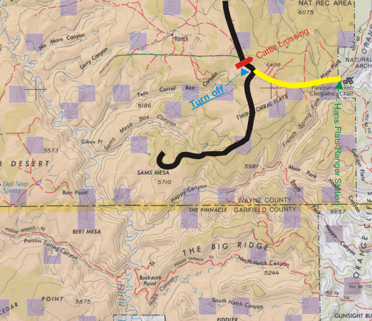
The entrance to Sam's Mesa is two and one-half hours from Green River, Utah. From I-70, take Utah Highway 24 south for 24 miles. Or, if you are coming from Hanksville, Utah from the south, take Utah Highway 24 north for about 6 to 10 miles and turn off to the right. If you get to the turnoff for Goblin Valley State Park, you've gone too far. Turn around there and back track. Actually, there are two entrances off highway 24 and either will get you to the road to the Hans Flats Ranger Station. That's where you are headed. If you ask anyone directions, ask about the Ranger Station. If you ask directions to Sam's Mesa, you will likely get a funny look and a "huh" from whoever you are asking unless they are a local, that is, live and ranch in the area. Almost without fail, those who travel this road are going to some portion of the Maze Canyonlands National Park.
A left hand (or right hand) turn just beyond the turnoff to Goblin Valley State Park will take you along a two-wheel-drive dirt road 41 miles southeast to the turn off (marked in blue) for Sam's Mesa. If you miss the turn off you will end up at the Hans Flats Canyonlands Maze District ranger station which is 46 miles from the Utah Highway 24. Also, on this Hans Flats Road, there are numerous other roads that fork and turn off. Stay on the main road (or the road that looks the most used). At one of the first forks, about 15 miles in, you will come to a BLM/Canyonlands information board. It will give you a map of the area along with all the don'ts. Turn right here.
The next major turnoff is about 15 miles up the road. That turn off (if you turn right) will take you to the "Robber's Roost" area, a legendary Butch Cassidy hang out. So, go straight here. You will recognize this area because there is a large open meadow/pasture area, likely with cattle visible. That is about where the map below begins, just after the turnoff to Robber's Roost.
Map Note:
The map below is a very basic road map. It does not depict all the trails and roads you will find on Sam's Mesa. So, don't think there is only one road on the Mesa, when in fact there is myriad of trails/roads.
You will pass a road coming in from the right, (that's the one I've highlighted in green) and then just after, you will descend ever so slightly into another more rolling pasture area with some neat red rocks to your right. You then should be very close to the cattle guard crossing I've marked in red on the map above. After you go over the cattle guard crossing, look for the next turn off to the right, kind of near the top of a small rise. That's the entrance to Sam's Mesa.
Very few folks visit Sam's Mesa, and then, only for a day drive. I have been on Sam's Mesa about 10 times over the past 5 or 6 years. It is very peaceful and has many great panoramic views of one of the tributaries that feeds Glen Canyon Reservoir, namely, the "Dirty Devil River." How's that for the name of a river. Anyway, once on the Sam's Mesa road, you can continue on for about 7 more miles with most vehicles. Eventually, you will come to the "Rubicon" of the trail. It's a wash out created during the big thunderstorms in the area around 1997 to 1998. Anyway, because of this spot, I recommend lockers or a winch to successfully negotiate this obstacle. Going down is not the problem, it's coming back up due to the steepness of the grade that will create difficulty. Generally, I recommend lockers for this trip because the mesa has various sandy areas that would not be fun to get stuck in and because there is not always a tree nearby to attach a winch to.
Because of the remoteness of this trip, and the fact that VERY few people venture on to the extended mesa, some of the roads may not have visitors for years at a time. This Mesa is a jewel that is bypassed by most who travel in this area because they are SO eager to get to the Maze portion of Canyonlands National Park. I've been to the Maze overlook, and but for a few spots along that road (excluding the Flint Trail which is a MUST in any 4 wheelers book), Sam's Mesa is a much more enjoyable experience, especially, if you don't particularly enjoy sharing your wilderness adventure with other would-be outward bound adventurers. Of course, the Maze overlook is spectacular and I recommend that you see that for yourself, just so you can tell your buddies that you've been there too, along with the other hoards you will pass along the way, not to mention all the Canyonlands' rules and regulations you will likely violate while trying to have a good time. Just so you'll know, the day I ventured to the Maze overlook, I left my faithful companion (the sheep/herdy dog in the pictures) to guard our campsite on Sam's Mesa so as not to violate the Canyonlands rule regarding the prohibition of pets traveling inside the Park. Yes, that includes pets inside a vehicle for any purpose whatsoever.